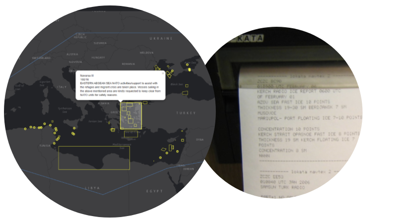
Released in 2019 as an extension to our Navarea warning app available on Android and Apple devices, Our Navarea warning API's are the one stop shop for nav area warnings, no more checking various websites for in-force and cancelled warning, use as a back up to your hardware receiver
We have advanced API's for our navarea warning dataset, perfect for integrating into your own systems and easy for developers to work with.
All warnings are checked and validated every 15 minutes so you never miss any data, all coastal warnings are included
|
NavArea
|
Year
|
Message
|
|---|---|---|
| Murmansk | 2026-03-27 13:17:00.413 | COASTAL WARNING WEST MURMANSK 121 CHART 17054
KOLA BAY
1. DIVING OPERATIONS FROM 01 TO 20 APR IN THE AREA 69-03-46.5N 033-12-13.5E 69-03-43.9N 033-12-46.0E 69-03-28.5N 033-12-38.0E THEN ALONG THE SHORELINE TO 69-03-24.6N 033-12-33.0E 69-03-26.5N 033-12-02.5E EXERCISE CAUTION WHEN SAILING 2. CANCEL THIS NR 21 APR= 271000 MSK GS- |
| Taiwan NTM | 2026-03-19 10:51:00.543 | 55 (T) Dongsha Island Waters – Firing Exercise
Dongsha Island Waters
Source Navy Headquarters, MND, letter No. 1150019563 dated March 12, 2026. Details 1. The live ammunition fire exercise will take place in April 2026. Regulated content is shown as attachment. 2. During the exercise period, all vessels are prohibited from sailing the exercise waters. In Area (Firing for CGA Exercise): 20°46'47.0"N, 116°35'01.0"E 20°36'27.0"N, 116°35'01.0"E 20°36'27.0"N, 116°52'12.0"E 20°46'47.0"N, 116°52'12.0"E Times (local): 2026-04-18 to 2026-04-18 0700–2200 2026-04-25 to 2026-04-25 0700–2200 NTM URL: https://navy.mnd.gov.tw/Files/Others/26-55(民-含附件).pdf |
| Taiwan NTM | 2026-03-09 13:17:00.53 | 45 (T) Taiwan Waters – Firing Exercise
Taiwan Waters
Source Air Force Headquarters, MND, letter No. 1150049962 dated March 4, 2026. Details 1. The live ammunition fire exercise will take place from April to June 2026. Regulated content is shown as attachment. 2. During the exercise period, all vessels are prohibited from sailing the exercise waters. Charts affected 0313 - 0338 - 0340 - 04502 - 04504 - 0471B In Area (A): 22°19'10.0"N, 120°37'48.0"E 22°21'59.0"N, 120°27'27.0"E 22°09'35.0"N, 120°41'00.0"E Times (local): 2026-05-05 to 2026-05-08 1200–1700, 1730–2100 2026-05-12 to 2026-05-15 1200–1700, 1730–2100 2026-06-11 to 2026-06-12 1200–1700, 1730–2100 2026-06-18 to 2026-06-18 1200–1700, 1730–2100 2026-06-22 to 2026-06-24 1200–1700, 1730–2100 2026-04-15 to 2026-04-16 1200–1700, 1730–2100 2026-06-25 to 2026-06-26 1200–1700, 1730–2100 In Area (B): 22°25'05.0"N, 120°26'48.0"E 22°07'00.0"N, 120°26'48.0"E 22°07'00.0"N, 120°40'48.0"E 22°25'05.0"N, 120°40'48.0"E Times (local): 2026-05-05 to 2026-05-08 1200–1700, 1730–2100 2026-05-12 to 2026-05-15 1200–1700, 1730–2100 2026-06-11 to 2026-06-12 1200–1700, 1730–2100 2026-06-18 to 2026-06-18 1200–1700, 1730–2100 2026-06-22 to 2026-06-24 1200–1700, 1730–2100 2026-05-19 to 2026-05-20 1000–1200 2026-05-26 to 2026-05-27 1000–1200 NTM URL: https://navy.mnd.gov.tw/Files/Others/26-45(民-含附件).pdf |
| Navarea XX | 2026-03-28 06:17:00.48 | NAVAREA 200 42/26 CHART 10100
BARENTS SEA
1. MISSILE AND ARTILLERY FIRINGS
01 TO 05 APR 0500 TO 1900 NAVIGATION PROHIBITED IN TERRITORIAL WATERS WITH DANGER BEYOND THEIR LIMITS IN AREA 70-03.6N 033-38.0E 70-03.6N 035-26.3E 69-31.5N 035-26.3E 69-31.5N 033-38.0E 2. CANCEL THIS MSG 052000 APR= NNNN |
| Murmansk | 2026-02-11 13:50:02.763 | COASTAL WARNING WEST MURMANSK 40 BOOK 3003
BARENTS SEA
1. CONTROL-CORRECTIVE STATION MDPS KANINSKY NO 1210 RANGE REDUCED TO 150 KM FROM 22 NOV 2023 2. CANCELLATION 30/24 AND THIS POINT= 111000 MSK HS- |
| Murmansk | 2026-02-09 14:16:00.243 | BARENTS SEA
MARINE RADIO BEACONS
1. SYETNAVOLOKSKIY 69-23.9N 033-30.0E NR 1250 CHANGED TO OPERATION ON DEMAND 2. TERIBERSKIY 69-15.1N 035-09.5E NR 1260 INACTIVE SINCE 01 APR 2024 3. OT 29/24 128/24 AND THIS POINT= 091000 MSK GS- |
| Shenzhen MSA | 2026-03-30 19:15:00.327 | SZ Maritime Safety Alert 30/26, Dapeng Bay, from April 1 to 12, Bluewater 02 vessel will carry out transport yard lifting to shore operations in the waters bordered by the following four points in Yantian Port Eastern Area: 22-34.77N 114-17.36E, 22-34.80N 114-17.39E, 22-34.45N 114-17.71E, 22-34.43N 114-17.68E. Please give way. |
| Arkhangelsk | 2026-01-14 08:50:02.183 | COASTAL WARNING ARKHANGELSK 3 BOOK 3003
BARENTS SEA
KKC MDPS KANINSKY NR 1210 REDUCTION OF RANGE TO 150 KM FROM 22 NOV 2023 = 141000 MSK GS- NNNN |
| Coastal | 2026-04-03 09:20:51.013 | PAKISTAN
KARACHI APPROACHES
CHARTS PAK 5 (INT 7314), 30 (INT 7315) AND BA 40 WRECK BUOY IN POSITION 24-46.45N 066-57.09E REPORTED MISSING MARINERS CAUTIONED |
| Navarea XIV | 2026-03-31 22:51:00.543 | VITI LEVU - WEST COAST
LAUTOKA HARBOUR - VUDA POINT
1. PIPE LAYING OPERATIONS BY CORAL BAY AND DIVERS IN PROGRESS DAILY BETWEEN 1900 and 0700 UTC UNTIL 20 APRIL 26 IN VICINITY OF A LINE 17-41.01S 177-23.29E, 17-41.79S 177-23.30E. WIDE BERTH REQUESTED 2. CANCEL THIS MESSAGE 210001 UTC APR 26 |
Start using Navareas for free by signing up. We also offer a monthly or yearly subscription to unlock more features.